


|
|
|
|
|
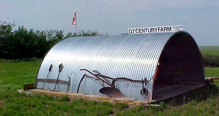
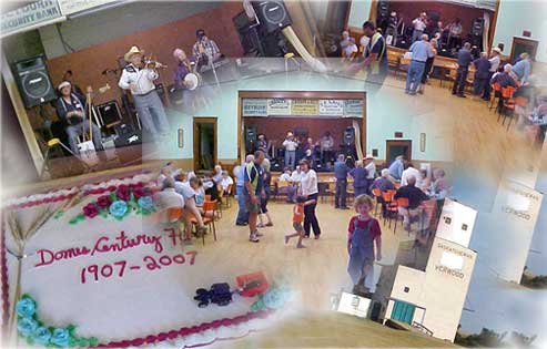
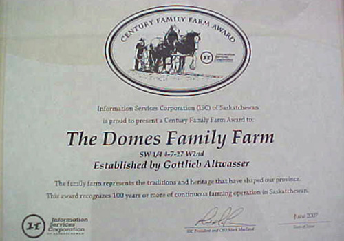
The Century FarmSW - 4 - 7 - 27 - W2 1907 - 2007
Saskatchewan Agriculture and Food introduced the Century Family Farm Award Program in 1981 to honour Saskatchewan's farm families and their role in the development of the province. To qualify, members of the same family must have farmed the land continuously for 100 years or more, live in Saskatchewan, and continue to operate the farm.
The Dominion Lands Act of 1872 offered settlers the tempting opportunity to apply for a 160 acre homestead for a modest $10 registration fee. By meeting the requirements of cultivating 30 acres, building a house and doing some fencing within 3 years, the applicant received a patent that officially certified ownership. They had an option to purchase the quarter section next to theirs as a pre-emption for about $3.00 per acre. When several townships in the Verwood area opened for homesteading in 1906, Gottlieb Altwasser filed homestead applications for himself and two of his sons.
The homestead application from Gottlieb Altwasser of Yellow Grass for SW-4-7-27-W2 was received on November 2, 1906 and assigned File No. 1300828 by the Department Of The Interior. Gottlieb obtained homestead entry on February 8th, 1907 and was granted the land patent in 1910. He also applied for pre-emption entry on the adjoining SE-5-7-27-W2 in 1908. The pre-emption land patent application was dated May 26, 1913 and later stamped "payment completed in full" January 2, 1917.
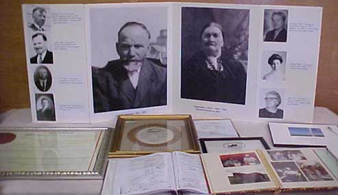
Gottlieb had left a will prior to his death in 1923 and his son Michael was appointed administrator of the estate by the court. The administrator was responsible to pay debts and expenses, to file required tax returns, to sell assets that needed to be sold, and to distribute all the remaining assets in accordance with the law or the Will. Periodically, the court required up-to-date financial records of the estate until the probate process was completed. Adolph "Archie" Domes, Michael's brother-in-law, oversaw the actual operation of the farm and provided Michael with the financial details required by the court.
The court records show that estate was settled in 1949 with Gottlieb's grandson Art Domes earlier purchasing the SW-4 and SE-5 in 1947. In 1955 Art sold the SW-4 to his Dad and in 1967 he sold the SE-5 to brother Herb. Why the estate wasn't settled sooner is unclear because there doesn't appear to be a litigation factor in play. Farm revenues paid the taxes, expenses and property improvements over this lengthy period and kept the land in family hands. Today Herb Domes owns the original two Altwasser quarter sections which, over 100 years later, are a part of Herb and Helen's Century Farm.
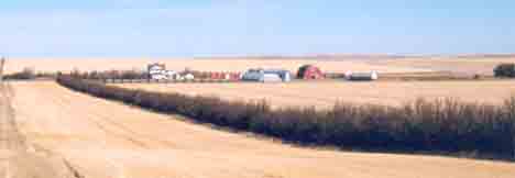
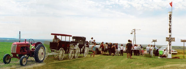
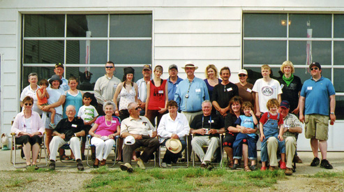
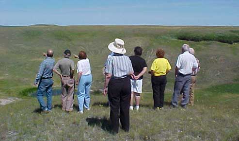
Herb and Helen's Century Farm, numbering about 2000 acres, contains three homesteads established by family members in 1907. All three could have qualified for Century Farm status, but the bureaucrats stipulated that only one Century Farm designation could be awarded per family by the Saskatchewan Government. Herb Domes decided to honour his grandfather by organizing a "Jamboree at the Junction" to celebrate this Century Farm Award during the 2007 Canada Day weekend. Local residents and direct descendents of Gottlieb Altwasser and his wife Euphrosine attended.
Saturday June 30, 2007. In The Middle of Nowhere on the top of a hill.
Seven Hundred years ago the horse had not yet been introduced to North America so everything was carried on a man's back which accounts for smaller teepees. The Plains Indian had learned to survive by following the migrating buffalo. It provided everything he needed - food, clothing and shelter. Later the white man used the buffalo chips for fuel to make a fire.
About five hundred years ago, in 1492, Columbus sailed the ocean blue. He was sent by Spain and made five trips in ten years time. He discovered Central America and some of both South and North America. Spain introduced the horse. The British sent Henry Hudson to discover the North West Passage. While in Hudson Bay, mutiny broke out and he and his faithful were put in a small rowboat never to be seen again. Other British explorers went further south. Many colonies were established along the East Coast of U.S.A. They were taxed by the British but had no representation.
Fast forward to about two hundred years ago. The Boston Tea Party was over, the U.S.A. had been born and Thomas Jefferson was the third President of the thirteen colonies who declared their independence from Britain. In 1803, Jefferson had made a deal with Napoleon Bonaparte called the Louisiana Purchase for all the land drained by the Mississippi and Missouri rivers. That includes the land we are sitting on today.
Fast forward another one hundred years. Canada was born and John A. McDonald was our Prime Minister. He did a Louisiana Purchase of his own, buying Rupert's Land from the Hudson Bay Company so he could build a railway to the west coast if they would join confederation. They agreed, the railway was built and the white man came. The buffalo disappeared and it was the end of an era for the Indians of the plains.
We are now ready to talk about the time Gottlieb came to the homestead. Saskatchewan and Alberta had just been born. He spent his first year in Canada at Yellow Grass waiting for this area to be opened for homesteading. He applied on November 2, 1906 at Alameda Saskatchewan, and received entry in January 1907. It was a winter of record snowfall. Sixty inches of snow fell in one day in northern California at Giant Forest. Over seventy three feet was recorded at Tamarack, California, that winter. Here in Saskatchewan, all time records were set causing great hardships.
We have excerpts from three written accounts to share with you.
My mother said you could still find snow in the coulees when they arrived at the homestead on July 13, 1907. She told of hauling sod on a stone boat from the nearby fireguard for the Legare Sheep Ranch to prepare the shack for winter. Also of planting potatoes and harvesting a crop of flat potatoes from under the heavy sod of the fireguard. A winter supply of hay was put up after breaking some land. The nearest water supply was a slough on the quarter directly to the east. We weren't smart enough to ask about such things, but I'm sure that is why Grandpa moved from his homestead to his pre-emption. He had 10 head of livestock that also needed water and pasture and both were available on the pre-emption. All he had to do was dig a well and put a fence around 40 acres. Both jobs were completed according to his application for patent. My twenty minutes (self imposed time limit) are gone so it's your turn to ask questions."
Anonymous: "What is a pre-emption?"
A person is eligible to preempt any available quarter section lying alongside the homestead, or separated therefrom only by a road allowance, on payment of a fee of ten dollars if he obtains entry for a homestead under the Act of 1908 and continues to own and reside upon the land included therein, and does not hold, or has not assigned his right to, or has not received patent for a pre-emption under that or any previous Act ; or has obtained entry for a homestead under the provisions of Chapter 55 of the Revised Statutes, 1906, or any previous Act in that behalf, and continues to own the land included therein, and does not hold, or has not assigned his right to, or has not received patent for a pre-emption under the present or any previous Act.(1)
Orval Altwasser: "How was the pre-empted quarter section paid for?"
By definition, Gottlieb didn't own the pre-emption but held the right to purchase it before anybody else. From known documentation, the exact details of the payments are unclear, but he obviously made all the right moves and met the prerequisites in effect at the time. Here is the best answer available from a book published in 1911.(1)
In the case of entries granted on or after February 1st, 1909, it is required that the house shall be worth at least 300 dollars before application for patent is made.
(1) "The Dominion of Canada", Griffith, W. L., Boston: Little, Brown and Co., 1911, page 234.
"We will be moving down the hill to the white man's meeting place where we have erected a trail marker where Grandpa built his home. It also served as church for the German settlers of the district. Follow me down the hill and we will pay tribute to Gottlieb and Euphrosine."
A Tribute to the Pioneers
The Rest of the Story continues at the trail marker.
"Someone once wrote these words to a song called Home on the Range.
And the deer and the antelope play. Where seldom is heard a discouraging word, And the skies are not cloudy all day." In my mind's eye I can see Grandpa Gottlieb standing on the highest hill on his homestead among the teepee rings and buffalo bones and singing these words to his creator. We know he was a man of God. We know he dedicated 1/2 of his house to be used as a chapel by the German settlers. A separate door opened directly into the chapel area from the outside. Five years later the town sprung up, and there was a need of a cemetery. He offered the town the land for this purpose.
We know he loved children; he was a teacher before coming to Canada. My uncle Bill Domes told a story about how he would kick a little dirt over a few pennies, and then take the children by the hand to a spot he thought might have some buried treasure. They became good friends when they were allowed to keep the money and it gave him great pleasure.
We know he loved the land. According to the archives in Regina, he was involved in six applications for homesteads; One for each of his three sons, his own and his neighbor, Paul Smith. Paul's son Raymond told me his dad had owned an 80 acre farm at Lang before coming to Verwood. I don't know any other details. Gottlieb was supposed to have a nice farm with an orchard back in the Ukraine, which he apparently walked away from. Why we don't know, but we think it was for freedom. All young men were drafted into the army for four years, no exceptions. Like Sitting Bull he came to Canada for freedom, but Sitting Bull nearly starved before surrendering and Gottlieb survived and prospered. He knew how to adapt to new conditions.
According to the archives, he lists a blacksmith shop as one of his buildings. We have displayed a few homemade hand tools that may have been used by him or made by him. It is probably a talent that was put to good use on the homestead.
We know he knew the importance of water. He had a cistern beside his house where he could store a few days supply for emergencies or bad weather. A shallow trough in his pasture was filled from a spring for the livestock to drink from. Nearby a shallow well supplied drinking water which was hauled from the coulee by stone boat. Later a dam was built across the coulee, much closer to the buildings, and later yet a deep well was dug in the yard where the windmill stands today.
Like John A. McDonald, he was planning for the future, but the future consisted of only sixteen years. He was 55 when he applied for his homestead. I'm sure he had an easier life in Europe, but like Christopher Columbus, the call for adventure and discovery affected him also. I always thought that Columbus sailed half-way around the world to discover America. One day I checked it out. He only sailed 1/4 of the way around the world. Gottlieb traveled much further - another thousand or two thousand miles for his adventure and discovery.
Euphrosine meanwhile was very much a part of all this. She raised a family of seven which is quite an accomplishment. Her children were all hard working and clean living people that she could be proud of. Legend has it that she was a demanding person, but we all know that for every successful man there is also a hard working wife who helped make him successful. We owe both of them our gratitude and a big tribute would be to sing the song "Home On the Range" for both these hard working God-fearing pioneers. After that I will tell you about the historic trails in this area. Please help me with the song; I hate singing solos and I don't intend to. ( A lusty group rendition followed.)
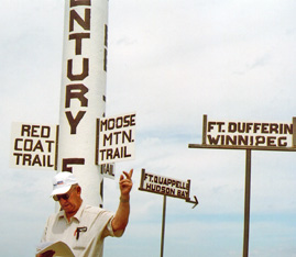
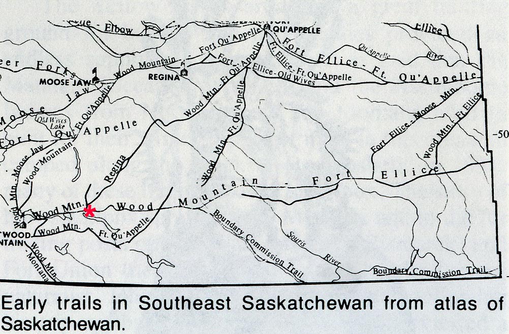
Historic Trails and Travel Routes
"In this area all trails led to Wood Mountain, probably because it was the most distinct feature of south central Saskatchewan. By that I mean that's the only thing that wasn't flat bald prairie. We had the Wood Mountain uplands here, the Cypress Hills over on the Alberta border and the Moose Mountain Hills over near the Manitoba border. So that's proboably one reason why Wood Mountain was important. All the trails in this area led to Wood Mountain." The biggest migration of settlers came from Winnipeg although many came north from the U.S.A. The Winnipeg trail led into what I call the Moose Mountain Trail which split to go on both sides of Willow Bunch Lake. The north side trail passed a mile south of Verwood heading to the valley at the north end of Willow Bunch Lake. The other trail or Wood Mountain Trail headed for the Hudson Bay Trading Post at Fort Qu'Appelle where you could sell the Buffalo hides and also the meat as pemmican. We discovered there were three trails between Wood Mountain and Fort Qu'Appelle. The first went south to Qu'Appelle, on to Yellow Grass-Lang area and joined the Moose Mountain Trail south of Ogema, about six miles south. As the west opened up, a more direct trail passed through Avonlea to the north end of Willow Bunch Lake. This is where the homesteads of Ed Wood, Gottlieb Altwasser and Paul Smith were located. Traffic was so heavy between the two points of Wood Mountain and Fort Qu'Appelle that there was talk of building a railroad along this trail. There were no roads then, they went by trails and if the trail was heavily enough travelled they built a railroad along it. Later another trail near Moose Jaw headed for Wood Mountain, and also a telegraph line to the Northwest Mounted Police during Sitting Bull's time in Canada. Another trail from Willow Bunch to Moose Jaw saw increased traffic after Legar� moved his trading post to Willow Bunch. Moose Jaw was closer than Regina, by 40 miles, making the trip two days shorter.
So it was puzzling why mother said Gottlieb built at the junction of two trails. Then I remembered the story of the 1906 - 07 winter and the flooding that spring. I think Willow Bunch Lake got much longer that spring and the trail was closed due to high water, maybe even a detour sign a few miles back east. The detour would be to the north to join the trail from Fort Qu'Appelle. It would start far enough east to miss the coulees running past Verwood, which would put the detour one mile north of town instead of one mile south as originally located. High water in the lake may have made the detour become the new route.
I'll just add another little story that came from my father-in-law who homesteaded on the south side of Willow Bunch Lake. He told a story about a trail that led across the upper end of Willow Bunch Lake. It was paved with stone about a foot or two under water. You would just give the horses head and slack lines and they would pick their way across on this stone trail. This was probably about the time when grandpa homesteaded. If there had been a trail across there and the water got higher, it got soft and mucky. Stones were probably hauled along and dumped off as the teams were going through these soft spots. A good pride of horses could pick its way across this stone trail even if it was under water. That's what makes me think the trail that went a mile south of Verwood into the bottom got switched to the north of Verwood.
The Red Coat Trail (Highway 13) is a modern invention to commemorate the march west by the N.W.M.P. The actual route was about 30 miles north passing between Lake of the Rivers and Old Wives Lake. The N.W.M.P. were following orders from Ottawa to eliminate the whisky trade and establish order in the west. On July 8, 1874, 275 officers and men (the entire Force) as well as horses, oxen, cattle, wagons, ox-carts, artillery, and agricultural equipment set out from Fort Dufferin, Manitoba. They pretty well followed the United States border until they got to to Weyburn, then they made a deep jog north to Avonlea. The animals were on the verge of exhaustion, the men were sick and had to help the horses pull the cannons, carts and wagons up over the hills. By the time they got to Cypress Hills they had their feet wrapped in gunny sacks, their shoes were totally worn out and their uniforms were just rags. They were looking for Fort Whoop-Up which is where the American fur traders were coming up from the Missouri river and selling whiskey to the indians. It was supposed to be at the forks of two rivers, but there was no sign of either Fort Whoop-Up or the whisky traders. The men were suffering under the heat and the hardships of the journey, while the shortage of water and feed continued to take its toll of the animals. Horses and oxen were succumbing at an alarming rate. In addition, weather conditions were deteriorating and an early winter was feared. At this point they were in such dire straits that they went south into the States to Fort Benton where they got new shoes, new clothing, food and supplies and asked about Fort Whoop-Up. As it turned out, Fort Whoop-Up was actually located further west than was originally reported. On October 9, 1874 they reached Fort Whoop-Up located at the junction of the St. Mary's and Belly Rivers. To their surprise, however, the site was almost deserted. The whisky traders had either fled across the border or had abandoned their illegal activities altogether. Today Highway 13 crosses Saskatchewan from east to west and is called The Red Coat Trail
One more story and I'm done. It is about three old timers who are hard of hearing.
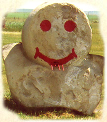
Two says: "No it isn't, it's Thursday." Three says: "I'm thirsty too, lets have a drink." Coffee, iced tea and cookies are going to be served in the garage. We have Kahlua to go in the coffee, Canadian and Kokanee for those guys who don't drink coffee. That's it for the formal activities today. The wife will serve the coffee and I will serve Kalhua to anybody who would like a little sweetener in the coffee. If you don't like Kahlua, I've got some coconut rum. I want you to be sure to check out the Happy Face before we go to town for happy hour, the supper and dance.
The Supper and Dance
The Pioneers.
Their Town.
Their Descendents.
Their Cemetery
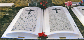
Verwood Cemetery, July 1, 2007.
Herb Domes' End Comments "After Sunday brunch and a visit to the cemetery, we checked out a large buffalo rub and an Indian grave, along with many tent rings along the edge of the mile wide valley carved by the melting waters of the last ice age.
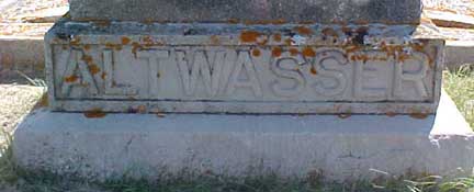
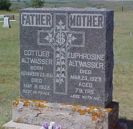
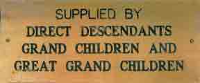
It was the end of a perfect weekend during which we accomplished four things. We got to know some relatives who had never been here before. We paid tribute to our ancestors. We marked the historic trails that were travel routes before roads and we celebrated our century in Western Canada." Verwood Cemetery 2008. As part of the Century Farm celebration, new grave covers for Grandpa Gottlieb and Grandma Euphrosine were ordered and installed. Small brass plaques at the foot of each cover acknowledge and thank direct descendants grand children and great grand children for their financial support of the project.
This is the centre of my universe. I was born 1/2 mile north, educated 1/2 mile south and lived here all my life. It is 500 miles to Winnipeg, 500 miles to Calgary, 500 miles to Denver and 500 miles to the Churchill River flowing to Hudson Bay. Closer to home we have Wood Mountain Uplands southwest; Big Muddy Valley southeast; Missouri Coteau to the east and Cypress Hills to the west. The area between is known as the Palliser Triangle or the Old Wives Basin, a watershed noted for low rainfall and prolonged periods of drought causing a shortage of fresh water."
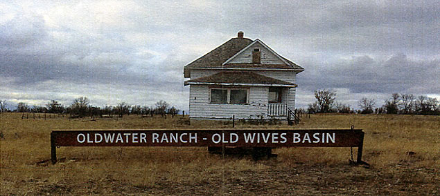
Helen Domes wrote in her 2017 Christmas letter..
Ten years ago we celebrated 100 years of farming. We also erected an historic marker called "Gottlieb Junction" to mark his homestead at the junction of two trails. The farm land has since been sold, but the ranch land was retained and this year got a new name. It is called Old Water Ranch - Old Wives Basin. Hope Grandpa Altwasser approves. Have a Merry Christmas.
From Helen and Herb Domes
|
| Copyright Notice All documents in the Destination: Yellow Grass web site are copyrighted. They may be freely used for personal, nonprofit purposes or linked by other WWW sites. They may also be shared with others for personal use, provided headers with copyright notices are included. However, no document may be republished in any form or embedded in public databases without permission of the copyright owner, since that represents theft of personal property. |